Al Thaqab Fort, Al Shamal
A crenellated 19th-century well fort in the north-west desert, restored in 2021 but not open to the public. What to know before you go.
Ath Thaqab, Al Shamal (inland, about 10 km from Al Zubarah)
Overview
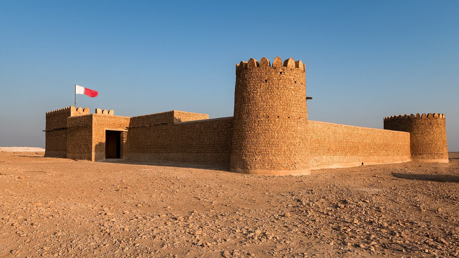
Al Thaqab Fort is a compact desert fort in the interior of north-west Qatar, about 10 km from Al Zubarah and only a couple of kilometres from its near neighbour, Al Rakiyat Fort. With its crenellated parapets, three round towers and one square one, it looks like a child’s drawing of a fort, and in the right light it is one of the most photogenic historic buildings in the north.
Like most small forts in Qatar, it was built to protect water. A deep well to the west of the fort supplied the people who lived and farmed here, and the fort gave them a place to shelter if they were attacked. Qatar Museums completed a full restoration in 2021.
Before you plan a trip, know this: Qatar Museums states that Al Thaghab Fort (its official spelling) is not accessible to the public, and asks people with questions to contact its heritage team. Older guides and blogs describe it as freely accessible, but that information is out of date. This guide covers the fort’s story, what it looks like, and how to fit a respectful look from outside into a day in the north. It suits people who collect Qatar’s forts, photographers and anyone exploring the Al Zubarah area in depth.
History and background
The fort’s age is uncertain. Qatar Museums says it most likely dates from the 19th century, although archaeological evidence hints that there may have been an earlier building here. When the latest restoration was completed in 2021, Sheikha Al Mayassa bint Hamad Al Thani, chairperson of Qatar Museums, announced that pottery and glassware found during the work may date back to the 19th century or earlier.
The name is a clue to the landscape. According to Qatar Museums, Thaghab refers to the water that collects at the bottom of a valley after rain. In a country with almost no surface water, a spot where rainwater gathered and where a deep well could be dug was worth defending, and that is exactly what the fort was for. It protected the well to its west and gave nearby families a refuge in times of conflict.
The north-west interior was more lived-in than it looks today. In the 18th and 19th centuries, the coast between Al Zubarah and Al Ruwais was dotted with trading and pearling settlements, and inland forts such as Al Thaqab and Al Rakiyat secured the water that those communities needed. Small farms still dot the land around the fort.
The fort was renovated in the 1980s, work that later observers felt had not been entirely faithful to the original. The most recent restoration, finished in 2021, was carried out by Qatar Museums as part of a wider programme to conserve the country’s historic forts and mosques using traditional materials.
What to see and do
The towers and crenellations
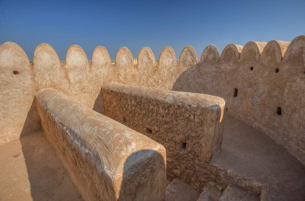
Qatar Museums describes the fort as rectangular, with circular towers at three corners and a rectangular tower at the fourth. The walls and towers are topped with rounded, tooth-like crenellations, which give the building its distinctive skyline. This is the feature you will notice first, and it is the one that photographs best from outside the boundary.
Rough stone and beach rock
The walls were built of rough limestone blocks and flat slabs of beach rock, known locally as faroush, set in mud mortar. The mix of materials gives the surface a textured, patchy look, especially in low sun. It is a good example of how builders in Qatar used what the land and the shore provided.
A bent entrance and date stores
According to descriptions of the site, the fort has a bent entrance, a doorway that turns a corner rather than opening straight into the courtyard, which made it harder for attackers to rush in. Inside, there were rooms for storing and processing dates, a staple food that could be kept for months. You will not be able to see these if the site is closed, but they explain why the fort is shaped the way it is.
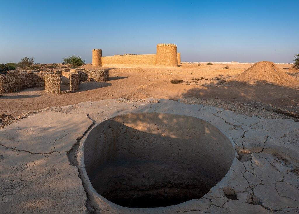
The well to the west
The reason the fort exists lies just to its west: a deep well that supplied the settlement. Photographs from 2021 show a large, round, stone-lined pit close to the fort. Look for it from outside, but never lean over or climb onto any well edge; old wells are deep and dangerous.
Comparing forts: Al Thaqab and Al Rakiyat
Al Rakiyat Fort stands only about 2.5 km to the north-east, and the two make a revealing pair. Al Thaqab has three round towers and one square one; Al Rakiyat has the reverse, three square towers and one round one. Both were built to guard water, both were restored by Qatar Museums in 2020 and 2021, and seeing them together shows how much variety there was within one simple type of building.
Photographing from outside
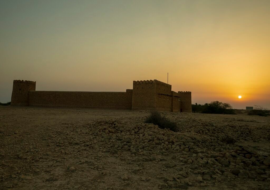
The fort looks its best at sunrise and in the last hour before sunset, when the crenellations cast long shadows and the stone glows orange. From outside the boundary, a moderate zoom lens lets you frame the round towers without trying to get closer than you should. Flying a drone requires permission from Qatar’s civil aviation authorities.
How to get there
Al Thaqab Fort lies in the desert of Al Shamal, roughly 10 km from Al Zubarah and a little over 100 km from central Doha. Allow around 1 hour 15 minutes to 1 hour 30 minutes each way.
- From Doha, take Al Shamal Road north towards Madinat Al Shamal.
- Head west towards Al Zubarah on the road that runs through the north-west interior.
- Use a map pin for the last part. OpenStreetMap places the fort at approximately 26.0328, 51.1171, a short distance south-west of Al Rakiyat Fort.
The main roads are paved, but the final approach may be on an unmade track. Some older guides recommend a 4×4; at the very least, drive slowly, stay on firm ground and avoid the area after rain. Park well away from the walls.
There is no public transport and there are no facilities at the fort. If you are using a taxi or a tour, bear in mind that the site is not open, so it only makes sense as a brief stop within a longer northern itinerary.
Best time to visit
Come between November and March, when the temperature allows you to be outside comfortably. In summer the interior of the north is extremely hot and exposed.
For photographs, aim for early morning or late afternoon, when the low sun brings out the texture of the stone and the shapes of the crenellations. Midday light is flat and harsh, and the fort blends into the pale landscape.
The area is quiet on any day of the week. A weekday visit means you are unlikely to see anyone else at all, which is part of the appeal, but also a reason to go with company.
Tips for your visit
- Respect the closure. Qatar Museums lists the fort as not accessible to the public. Do not climb fences or enter through gaps.
- Ask about access properly. If you have a genuine research or photography interest, email Qatar Museums’ heritage team at infoheritage@qm.org.qa.
- Do not trust old blog posts. Many describe the fort as open and free to wander. That is no longer the case.
- Pair it with Al Rakiyat. The two forts are so close that it makes sense to see them together, then carry on to Al Zubarah.
- Stay clear of wells. Old wells and pits in this area can be deep and unfenced.
- Respect the farms. Private farms surround the area. Do not drive onto farm tracks or photograph people without permission.
- Tell someone your plans. Mobile signal and passing traffic can both be sparse.
What to bring
- Water and snacks
- Sun protection
- Sturdy shoes
- A camera with a zoom lens
- Offline maps with both forts pinned
- A fully charged phone
Combine it with nearby places
Al Rakiyat Fort. About 2.5 km to the north-east, this restored well fort has the opposite tower arrangement: three square towers and one round. It is also listed as temporarily closed, so check before you go.
Al Zubarah Fort and Archaeological Site. The UNESCO World Heritage Site is roughly 10 km away and is open to visitors, with a museum in the 1938 fort and a shuttle to the excavated town.
Al Jumail Abandoned Village. On the coast to the north, this empty pearling village with its standing minaret can be viewed from outside its fence.
Al Ruwais Mosque and Old Port. The historic mosque and harbour at the northern tip of Qatar are the best place nearby for coffee, food and fuel.
Frequently asked questions
Can you visit Al Thaqab Fort?
Not officially. Qatar Museums states that the site is not accessible to the public. You may be able to see the exterior from outside the boundary. For enquiries, contact infoheritage@qm.org.qa.
How old is Al Thaqab Fort?
It most likely dates from the 19th century, according to Qatar Museums, though there are signs of earlier activity on the site. Pottery and glass found during the 2021 restoration may be 19th century or older.
What does the name mean?
Qatar Museums explains that Thaghab refers to water collecting at the bottom of a valley after rain. You will see the name spelt Al Thaqab, Ath Thaqab and Al Thaghab.
Why was it built?
To guard a deep well to the west of the fort and to give nearby residents a place of safety during attacks.
Do I need a 4×4?
The main roads are paved. The final approach may be unpaved, and some sources recommend a 4×4, so drive carefully in an ordinary car and avoid it after rain.
Is it worth the drive if it is closed?
On its own, probably not. As a short stop combined with Al Rakiyat, Al Zubarah and Al Ruwais, it adds a striking piece of desert architecture to a full day in the north.
Last checked October 2026. Hours, fees and access can change, so confirm with the official source before you go.
More places nearby
All places →
Run a tour, café or stay near Al Thaqab Fort, Al Shamal?
List your business free on Companies in Qatar, or get featured on Qatar Unseen in front of people planning their trip.